Wu, A., Convertino G., Ganoe C., Carroll J. M., & Zhang X(L). (2013). Supporting collaborative sense-making in emergency management through geo-visualization. International Journal of Human-Computer Studies. 71(1), 4-23.
Convertino, G., Mentis, H., Rosson, M.B., Carroll, J.M., Slavkovic, A., and Ganoe, C.H. (2008). Articulating Common Ground in Cooperative Work: Content and Process, CHI 2008 (Florence, Italy, April 5-10, 2008), pp. 1637-1646. ACM Press.
Convertino, G., Wu, A., Ganoe, C.H., Zhang, L., Hoffman, B. and Carroll, J.M. (2008) Designing Group Annotations and Process Visualizations for Role-Based Collaboration. chapter in Social Computing, Behavioral Modeling, and Prediction, Liu, H., Salerno, J. J. and Young, M. J. Editors, pp. 197-206.
Convertino, G., Wu, A., Ganoe, C.H., Zhang, L. and Carroll, J.M. (2008). Modeling and Supporting Common Ground in Geo-Collaboration. First International Workshop on Social Computing, Behavior Modeling and Predicton (Phoenix, AZ, April 1-2, 2008).
Schafer, W.A., Ganoe, C.H. & Carroll, J.M. (2007), Supporting Community Emergency Management Planning through a Geocollaboration Software Architecture, Computer Supported Cooperative Work (CSCW): The Journal of Collaborative Computing, Special Issue on Community Infrastructures, Vol. 6, Nos. 4-5, 501-537.
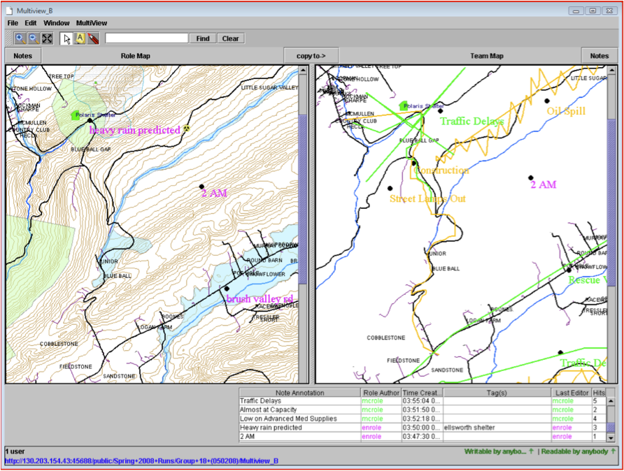
Convertino, G., Zhao, D., Ganoe, C.H., Carroll, J.M. & Rosson, M.B. (2007), A Role-based Multiple View Approach to Distributed Geo-Collaboration, proceedings of HCI International 2007: HCI Applications and Services, 561-570.
Carroll J.M., Mentis H., Convertino G., Rosson M.B., Ganoe C., Sinha H., Zhao D. (2007) Prototyping Collaborative Geospatial Emergency Planning. Proc. 4th International ISCRAM Conference, 105-113.
Convertino, G., Ganoe, C. H., Schafer, W., Yost, B., and Carroll, J. M., A Multiple View Approach to Support Common Ground in Distributed and Synchronous Geo-Collaboration, Coordinated & Multiple Views in Exploratory Visualization 2005 (CMV'05), 5 July 2005, London, UK, pp. 121-132.
Schafer, W. A., Ganoe, C. H., Xiao, L., Coch, G., and Carroll, J.M., Designing the Next Generation of Distributed, Geocollaborative Tools, Cartography and Geographic Information Science (CaGIS) Special Issue on Geovisualization and GIScience, vol. 32, no. 2, April 2005, pp. 81-100.